Direct-to-device satellites are being deployed in LEO and VLEO but scale is required for mainstream services
20 November 2024 | Research and Insights
Article | PDF (4 pages) | Satellite–Telecoms Integration
Early stage direct-to-device (D2D) constellations are being launched in low-Earth orbit (LEO) and very low-Earth orbit (VLEO) and the industry is in the early days of building scale towards global, continuous service. SpaceX’s announcements about its direct-to-cell (DTC) constellation and AST SpaceMobile’s launch of its first five production satellites are solid progress. However, performance data from the SpaceX constellation and AST’s severely limited coverage highlight that significantly more scale is needed to operate the thousands of LEO or VLEO satellites that are required for continuous connectivity.
Hurricane Milton: a real emergency test scenario
Connectivity was put to the test recently during the US hurricane season. Days before Hurricane Milton hit Florida, the US Federal Communications Commission (FCC) approved sending SMS texts using Starlink DTC satellites in areas that were previously affected by Hurricane Helene and where Hurricane Milton would pass. T-Mobile customers in areas affected by both hurricanes would be able to send emergency alerts and SMS messages over Starlink’s satellites with D2D capabilities at no cost. The FCC’s temporary approval came in the middle of a fierce debate about SpaceX’s request to relax rules linked to out-of-band emissions. There is some speculation this request was made because the current generation of Starlink D2D satellites has some flaws or limitations in terms of interference mitigation, which is a huge blow given that hundreds of satellites are already in orbit. Until the FCC’s approval, the Starlink DTC/D2D constellation was only allowed to operate in a T-Mobile-controlled environment as previously reported.
In addition to the temporary use of Starlink satellites for SMS services, users of any US mobile network with iPhone 14 or later can use Apple’s Emergency SOS service via the Globalstar satellite network, when off the grid with no cellular and Wi-Fi coverage. These networks can save lives. However, the Starlink DTC service was offered by SpaceX on a best-effort basis because, even with 222 orbiting satellites, the network cannot yet provide continuous service.
Status update: Starlink’s VLEO DTC constellation
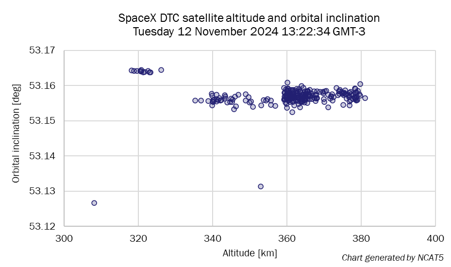
SpaceX asked the FCC to allow it to operate Gen2 DTC satellites in VLEO altitudes, specifically between 340km and 360km. This was a departure from the original plan to use LEO altitudes. It is unclear if the FCC approved such a modification, but daily observations using Analysys Mason’s Non-GEO Constellations Analysis Toolkit version 5.0 (NCAT5) confirm that all Starlink DTC/D2D satellites are orbiting at VLEO altitudes (Figure 1).
Figure 1: SpaceX’s 222-satellite D2D network

VLEO has so far been less popular than LEO because of challenges when operating in VLEO, including atmospheric drag and the presence of material-degrading atomic oxygen that shorten the lifetime of orbiting satellites. The lower the altitude, the higher the number of satellites that are needed for continuous coverage, so the combination of more satellites that have short lives can be a business case breaker. However, SpaceX claimed in its modification request that results of testing D2D satellites in VLEO altitudes were better than expected and that the cost of quicker replacement cycles would be a burden that the company would be able handle.
Predictive analysis of Starlink’s DTC wait and service times
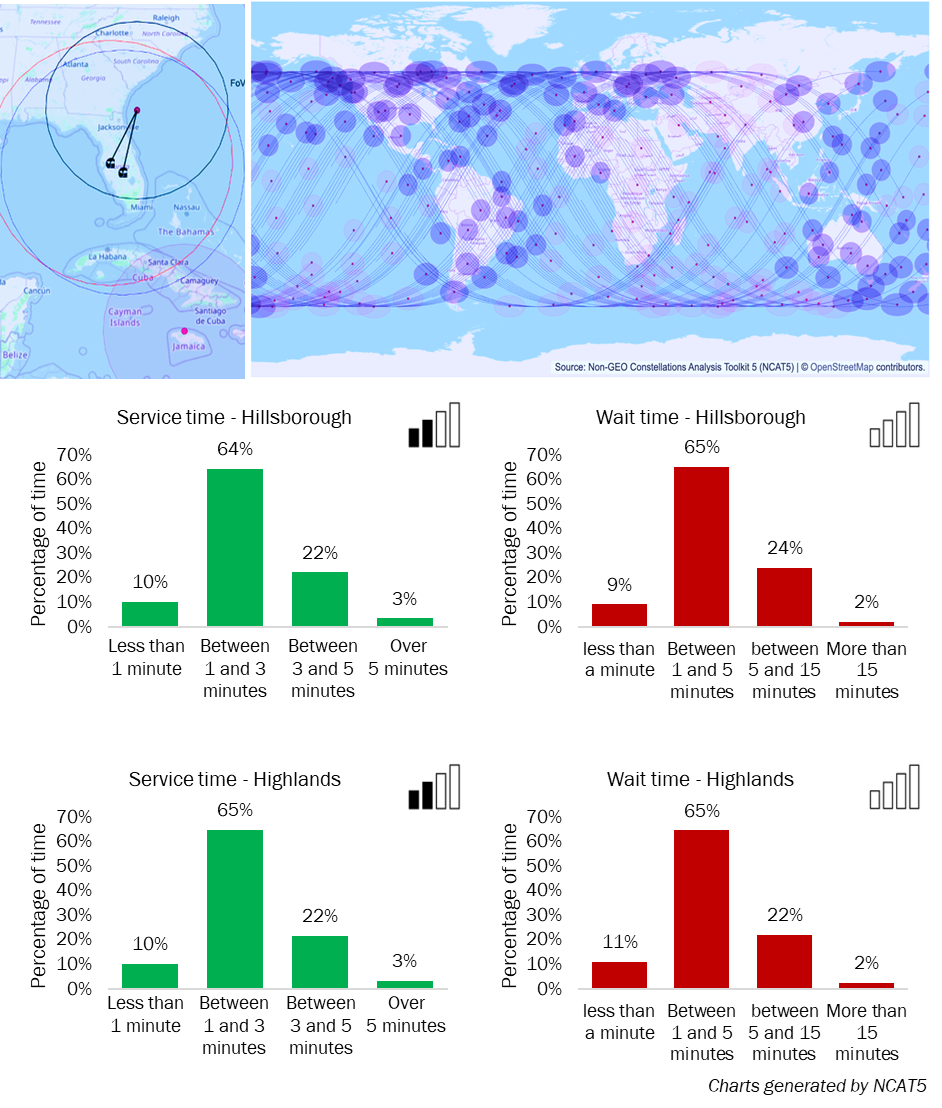
In anticipation of possible service outages caused by Hurricane Milton, a predictive simulation using the NCAT5 platform was shared (openly) online so that T-Mobile users could know what to expect in terms of satellite service response times as the hurricane passed. The predictive assessment focused on the populated Tampa and Orlando areas, both within the uncertainty cone of the projected path of the hurricane. This analysis was shared 8 hours before the hurricane landed and was repeated after the hurricane passed using the latest satellite ephemerides data. The file was updated with expected Starlink DTC satellite visibility data for the two Florida counties most affected by power outages (Hillsborough and Highlands) and included predicted data with 3-second granularity from 11 October at 7:30am to 12 October at 8:00am US eastern time (Figure 2).
Figure 2: Predictive analysis of Starlink DTC wait times, NCAT5

The main conclusion from this predictive simulation was that, even with 222 satellites, users that needed to rely exclusively on the Starlink T-Mobile service would need to wait up to 15 minutes for a Starlink DTC satellite to become visible so that alerts and text messages could travel to T-Mobile’s core network (and more than 15 minutes in a few instances). Once a satellite became visible, it would be available up to 3 minutes 75% of the time, after which users would need to wait for the next satellite pass.
It is unknown if this look-ahead information helped affected Floridians, but the Starlink DTC network was indeed busy supporting locals when the hurricane hit and after it passed. A T-Mobile executive mentioned in an interview with ABC News on 13 October that the Starlink DTC network carried 120 emergency alerts and over 120 000 text messages.
D2D satellite constellations are already having an impact, as demonstrated by T-Mobile and Starlink in Florida and previously by Apple and Globalstar. However, service ‘wait time’ statistics show that scale, primarily in the form of thousands more D2D-capable satellites in LEO or VLEO, will be essential for establishing and maintaining continuous connectivity across a wide latitude range.
Article (PDF)
DownloadAuthor

Christopher Baugh
Partner, expert in space and satellite telecomsRelated items
Tracker
Satellite consumer D2D news and deals tracker 2024–2025
Tracker
Consumer and enterprise broadband via satellite news and deals tracker 2024–2025
Report
Analysys Mason research and insights topics for 2026

